Montana in 30 Years: Earthquakes
Interview with Professor Michael Stickney,
Montana Bureau of Mines and Geology Montana Technical University
Michael Stickney grew up in Missoula and received a Bachelors degree and a Masters degree, both in geology from the University of Montana. As a student, he worked in the Earthquake Research Laboratory. The Montana Bureau of Mines and Geology hired Mike in 1980 to conduct a study of faulting and earthquake hazards in the Helena Valley. In 1982, Mike was appointed Director of the Bureau’s Earthquake Studies Office and promoted to senior research geologist in 2002. He received an honorary PhD from Montana State University in May of 2004. He is a member of Seismological Society of America, the Tobacco Root Geologic Society, and represents the Bureau at the Yellowstone Volcano Observatory. His professional interests include regional seismic monitoring, seismicity and faulting in Montana and Quaternary geology. Mike has written extensively on seismic related topics and historic earthquakes of the northern Rocky Mountains.
30 Years is not even an eyeblink in geologic history, but do you see increases in earthquake activity or severity over that period of time?
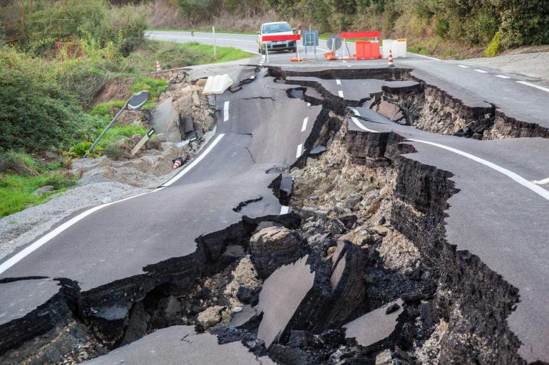
Earthquakes by their nature, are random events, which may see periods of increased or decreased activity. We have not observed any systematic increase in significant earthquake activity during the nearly four decades of seismic monitoring here at the Montana Bureau of Mines and Geology’s Earthquake Studies Office. We do report more earthquakes now than we did several decades ago because the seismic monitoring network has expanded and improved, which allows us to detect and report more of the small-magnitude events that previously went unreported. However, the potential adverse effects of a major earthquake here in Montana are increasing through time because of the expanding infrastructure that accompanies our state’s growing population.
What parts of Montana seem to have the greatest potential exposure to damaging quake activity through 2050?
Western Montana has the highest earthquake hazard because of the Intermountain Seismic Belt, which extends from northwestern Montana to Yellowstone National Park and on southward through Salt Lake City, UT and into southern Nevada. The Montana portion of this ~150-mile-wide belt experiences frequent small (less than magnitude 2) earthquakes (5 to 10 per day on average) and occasional larger earthquakes. All of Montana’s major historic earthquakes have occurred in western Montana. While the vast majority of seismicity occurs there, eastern Montana is not immune from earthquakes as demonstrated by the occurrence of a magnitude 5.3 earthquake centered near Scobey on May 15, 1909. The Intermountain Seismic Belt passing through western Montana is clearly delineated on the U.S. Geological Survey’s national seismic hazard map.
People don’t generally think of Montana as an earthquake or fault zone, but we understand that there is one fault in particular, the Mission Fault, which could produce a major seismic event over the next 30 years. Where does this fault lie, and what concern do you have about a damaging event from this fault line?
There are about 80 faults in Montana that have the potential to produce future earthquakes. Almost all of these faults lie within the Intermountain Seismic Belt in western Montana. One of the largest faults in northwestern Montana is the Mission Fault, which extends northward for 25 miles along the western base of the Mission Mountains roughly between the latitudes of St. Ignatius and Ronan. The Mission Fault is well-studied and these studies indicate that slip along this fault about 7,700 years ago produced a major earthquake. These studies indicate that major earthquakes occur along the Mission Fault every 4,000 to 8,000 years. While nobody can predict earthquakes, the potential for a major earthquake in the Mission Valley is very real. A map of seismic shaking produced for a hypothetical scenario of a magnitude 6.9 earthquake on the Mission Fault suggests strong seismic shaking from Missoula to Kalispell and severe shaking between Arlee and Polson.

The “big one,” of course, is the Yellowstone caldera, which even today creates swarms of quakes. What is the outlook for earthquakes from this area, and how could Montana be impacted?
Yellowstone Park sits atop a large volcanic caldera which has produced three cataclysmic eruptions over the past 2.1 million years. Fortunately, these super volcanic eruptions are exceedingly rare. Much more common—but still very rare from a human perspective—are the 70 or so smaller eruptions (most of which affected nothing outside the Park) that have occurred since the last super eruption 640,000 years ago.
Yellowstone and the surrounding area are very seismically active, with several thousand earthquakes recorded there each year. The vast majority of these earthquakes are too small for people to notice but a major earthquake occurred just outside the Park in August 1959. The Hebgen Lake earthquake had a magnitude of 7.3 and produced perceptible shaking from Salt Lake City, UT to Edmonton, Alberta and from the Pacific Coast to the Dakotas. Up to 20 feet of displacement occurred along two faults along the north edge of Hebgen Lake. Severe shaking damaged Hebgen Dam and triggered a major landslide that dammed the Madison River to form Earthquake Lake. Although this was in an area with a low permanent population, 29 people lost their lives in the landslide and rock falls.
What improvements in seismic science do you foresee over the next 30 years?
Hopefully 30 years from now, the state-of-the-art seismic monitoring systems that currently operate in and around west coast cities will be deployed in Montana, providing a few seconds to minutes of warning of impending shaking after a significant earthquake occurs. With continuing improvements in communications and computers, additional types of data, such as real-time global positioning system data, will be incorporated into earthquake monitoring systems. Such systems could provide nearly instantaneous information about the location and size of an earthquake. The holy grail of seismology is earthquake prediction, however our current understanding of this very difficult problem makes this goal seem unlikely in the next three decades. If the current pace of innovation is any guide, the seismological revolution will continue.
Do you feel that the local government bodies in Montana are adequately prepared for response to damaging quakes?
Yes, government bodies have plans in place to respond to an earthquake. Montana county governments, tribal governments, and the State of Montana have created pre-disaster mitigation plans that are updated at regular intervals. These plans identify potential hazards, including earthquakes, and suggest projects to mitigate their effects. The State of Montana also has emergency response plans and disaster recovery plans that take effect in the aftermath of a damaging earthquake.
What advice, if any, do you have for the construction industry in Montana with regard to building with the ongoing threat of seismic activity?
U.S. building codes take into account the seismic hazards in different regions of the country. When built according to code, buildings are designed to protect the life and safety of its occupants. In some post-earthquake inspections of buildings that did not perform as expected, shoddy or inadequate construction was discovered. Construction that conforms to the established building codes will result in earthquake resistant structures. A major challenge will be retrofitting older buildings, constructed before modern building codes took effect, to make them earthquake resistant.
Remind us all of the precautions and actions people might take in the event of a damaging quake.
Earthquake preparedness is an important aspect of living in earthquake country. Most earthquake hazards result from falling or toppling objects and can be avoided by taking common sense measures.
When the earth begins to shake, resist the urge to run outside and instead duck under a desk, table, or other piece of furniture, cover your head with one arm, and hold on to the furniture with the other. After the shaking stops, go outside until it is safe to return.
Never place heavy objects above locations where you spend time, as these may fall during an earthquake.
Anchor tall furniture, such as book cases, to a wall so they cannot topple during shaking.
The Montana Bureau of Mines and Geology has developed a story map on Seismic Hazards in Montana, which is intended to increase public awareness of earthquake hazards and educate the public about steps they can take to prepare for earthquakes. It includes information on historical Montana earthquakes, how ongoing seismic activity is analyzed, and how to prepare for future earthquakes and mitigate their effects.




Leave a Comment Here